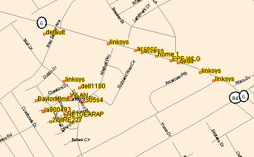
Another interesting use of a GPS device is to map out local wireless access points in your neighborhood. When the GPS is connected to your laptop computer, you can run a program like NetStumbler to record the coordinates of the wireless signals you discover. The mapping program, JiGLE, uses these coordinates and the signal strength of the detected wireless networks to map the approximate location of the source of the wireless access point that was detected. To create a map like this one on a Windows XP computer, follow the steps below.
- Download and install NetStumbler from http://www.netstumbler.com/downloads/.
- Download and install JiGLE and the vector map for your county from http://www.wigle.net/gps/gps/GPSDB/dl/.
- Connect your GPS to your laptop with a data cable and configure your GPS to send a NMEA compatible signal in your Interface Setup screen.
- Start NetStumbler and begin driving through your neighborhood. Each time NetStumbler picks up a signal, it will show its listing on the main screen and generate an alert sound.
- When you are finished with your drive, close NetStumbler and save the NS1 file it generates for you in your C:\JiGLE directory as "nt.ns1".
- From the command line or the Run menu, launch JiGLE by typing "C:\JiGLE\run.bat -getstumble nt.ns1".
- Then choose your county map from the drop-down list and you will be able to pan/zoom around the map to view the wireless access points in your neighborhood.
No comments:
Post a Comment