Showing posts with label Resources. Show all posts

Thursday, April 26, 2012

Geocaching Pen Follow-up

Last night, the True Utility Telepen Telescopic Pen I ordered from Amazon arrived.  Naturally, I had the box open before I was even in the front door.  It is perfect!  Although it took me a few moments to figure out that there was no release mechanism for the pen from the cap -- just really tight friction -- it was exactly as I had hoped.  The collapsed length is just a little longer than traditional house keys and just a little shorter than traditional car keys.

Whenever I drive to a geocache now, I am guaranteed to have a pen with me!!!


Another exciting thing related to this pen was being mentioned on two fantastic podcasts.  If you aren't already a listener to the new Cache-A-Maniacs podcast network and the fantastic PodCacher podcast, you should be!  Both of these geocaching podcasts are regulars for me and feature the best news and information from the world of geocaching.  These are the two episodes that mention me sharing information about this pen:

   GeoGearHeads Beta.16: Hosting Geocaching 101s II

   Podcacher Show 368.0: An Unexpected Find

Monday, April 16, 2012

Geocaching Pen

I generally don't post many product links on this website, but sometimes I find a particular product that just blows my mind on its usefulness. Normally, I wouldn't put a pen in this category, but I've had too many experiences lately where I happen to find a cache while out-and-about without a pen handy to sign the log. In fact, this weekend, I resorted to scratching my name in a log with a muddy toothpick because I found a cache while out of town and didn't have a pen with me in the car.

This pen is a tiny, telescoping pen that attaches to your keyring or other keychain. With this, if I drive to a cache, I'm guaranteed to have my pen with me!

True Utility Telescopic Pen on Amazon.com


Tuesday, February 15, 2011

Blog Fade, Cache Fade, and Resurrection - Part 2

In the time since my first post in 2005, blogging technology has changed dramatically, so it was time that this site change as well.  In part two of this post, I want to briefly share what is new and different on this site before I return you to your regular geocaching programming. 

For those who might not know or remember what this site looked like before - and I'm not so vain to assume that you do - this site used a somewhat customized version of the Rounders 3 template provided in the old template library in pre-2008 Blogger.  

The old blue/green/tan template worked well for a number of years.  But it was not widget-based, so any customizations including side-bar changes required direct editing of the main template file itself.  To work around this limitation, I used multiple embedded JSON feeds from delicious.com (del.icio.us back then) to display both the popular posts list, tag-based categories, and the other blogroll-type lists on the page.  At the time, this was a fairly unique use of social bookmarking.  Now, it is just old and kludgy.

The new site uses a version of the Picture Window theme built from the Blogger Theme Designer that was customized slightly for my personal use.  It is widget-based and allows me to reorganize and rearrange the sections of this blog simply by dragging-and-dropping.  It uses Blogger's built-in (powered by Google) search, popular posts lists, list of followers, and category labels.

The old site contained Google Adwords at the top of each and every post.  The new site doesn't.  I still use Google Adwords, but never within the posts themselves.  They are limited to the small gap between posts and only appear after every 3rd post.

I also changed the manually-coded sharing/subscribe section to use a customized widget from http://www.addthis.com/.  This new "Bookmark and Share" section displays popular sharing/bookmarking options that are unique to each visitor based on the sites and services that each visitor has used recently.  All visitors will see the GoogleFacebook, Twitter, Instapaper, and Evernote buttons [my personal fave five], but the rest could differ for each visitor.  For example, if visitor "A" normally shares links on Digg, that button will appear higher in the list.  If visitor "B" normally shares links on Tumblr, that button will appear higher in the list.  If visitor "C" normally bookmarks links on Diigo, that button will appear higher in the list.  Altogether there are over 300 various bookmarking and sharing services available to users that can be accessed under the last AddThis button.  So regardless of where you like to share or bookmark links, you can now do so quickly and easily!

Friday, September 15, 2006

PodCacher Ultimate Motivational Primer

Sonny and Sandy at Podcacher.com have created a really great 2 minute audio file designed to pump you up and get you ready to go caching!

Check out The Caching PUMP!

Tuesday, July 25, 2006

Cheap Signature Cards - Update

My 250 free geocaching signature cards from VistaPrint have arrived! The cards I ordered look exactly like they did on the online preview and arrived much faster than I anticipated. The edges are clean, the text is clear, and the overall quality is really great. I still wish I had more customizations and designs to choose from at no charge, but I can't complain about free. Thanks VistaPrint!

Friday, July 21, 2006

My Stats

This week, Mike and Barb at http://www.jestcaching.com/ wrote about a really exciting new program for all of the stats junkies out there! This is from their post titled "Review of CacheStats."
I stumbled across a program called CacheStats written by abcdmCachers. As many of you know I am a bit of statistics freak. This program is really cool. If you are a premium member you can do a pocket query on your finds. Once you import the unzipped GPX file it displays a bunch of interesting stats.
I, of course, immediately downloaded and tried out this program myself. As you can see below, it works great! I did discover that it won't take a GSAK .gpx export of your finds. It relies solely on the MyFinds pocket query to get its data. I was able to quickly mark my FTF's and even declare a couple of "favorite" caches. The example below is a slightly condensed view of the results that is displayed in an iframe because of limitations with Blogger.com's handling of HTML tables.


Friday, July 14, 2006

Geocaching Stats Bar Changes

For anyone who uses the Geocaching.com stats bars on a webpage, forum signature or anywhere else, you will need to update your signature code. Groundspeak moved all images to a new server and the web is littered with thousands of broken stats bar images.

EDIT: Nevermind most of this post. Raine, a Groundlackey, just fixed the server so that either the old WWW or the new IMG server name will work. However, if you want to update your page to the new server anyway, you may continue reading the rest of this post.

Luckily, it is a quick and easy fix. All you have to do is change the "www" to "img" in the IMG tag of your HTML code. That typically is the tag that looks like "<img src= . . . ." However, be sure NOT to change the tag that looks like "<a href= . . ." or the link back to your profile will be broken.

For example, find the line that looks like this:
<img src="http://www.geocaching.com/stats/img.aspx?txt=&uid=4322750f-a3d6-4ee9-8ba6-c71b8da22675">

and change it to look like this (use your own UID code of course):
<img src="http://img.geocaching.com/stats/img.aspx?txt=&uid=4322750f-a3d6-4ee9-8ba6-c71b8da22675">
Also, if you've never created your own stats bar for a webpage before, you can generate one with the correct code changes at http://www.geocaching.com/my/statbar.aspx.
 

Friday, June 30, 2006

Stats and Rankings

Stats! Huh-yeah.
What is it good for?
Absolutely nothing.
Uh-huh!


Many geocachers that I've met in person or online are absolutely obsessed with stats. You may even be one of them. If so, this post is for you!

Part of any great sport or game is the element of competition. Geocaching is no different! Well, almost no different. Geocaching is a little different because there are so many unregulated variables that make a true comparison virtually impossible. There are at least 5 different cache listing services - each with their own rules or guidelines. There are also so many different views of what makes a "good" hide or a "true" find.

  • Does a group hunt count for individual finds?
  • Does a find count if you've had to call or ask for help?
  • Are harder hides worth more than easier ones?
  • Should a foreign cache logged at a local event be allowed?
  • Can a find still be logged on disabled caches?
Personally, I think this short paragraph from a May 2005 article by Chuck Williams in LowCountry Weekly called "An Insider's Look at the Geocaching Controversy" sums this up the best.
In geocaching, everyone who seeks a geocache is a winner, whether they find the actual geocache container or not. The real thrills are the search and the locations, not the random key chains, Mickey D toys and other trinkets that fill a geocache container. The real nugget that the geocacher seeks is the logbook to sign and prove that s/he has really been there and found that. The scorecard is a personal one.
For me, the real thrill of geocaching is the hunt without all of the stats involved. But with that in mind, there are still several sites on the Internet dedicated solely to tracking stats and ranking geocachers based on their total number of hides, finds, and hide-to-find ratio. Even I'll confess to browsing these from time to time to see where I fit in the grand scheme of geocaching. These are two of the main national Geocacher Ranking sites.
  • KeenPeople.com Stats - This site allows geocachers to register themselves and record their own statistics from any listing service which are then used for the overall or state-wide rankings. Geocachers are allowed to enter how many of each type of cache they have found and hidden. Cachers can also record many other details like how many other Geocachers they've met, how many travel bugs they have found or released, how many times they have CITO'd a cache site, how many times they were FTF, or how many states they've cached.
  • Grand High Pobah - This site automatically grabs geocaching statistics from a select number of "high profile" Geocaching.com geocaches from each country and state. It only tracks the number of hides and finds from each cacher, but since it does it automatically, the stats are much more accurate and up-to-date than the other ranking sites. Unfortunately, this site only displays cachers with over 200 finds and cachers must have found one of the "high profile" geocaches in their state in order to appear in the rankings.

Thursday, June 01, 2006

GPS Visualizer Tutorial

"GPS Visualizer is a free, easy-to-use online utility that creates maps and profiles from GPS data (tracks and waypoints), street addresses, or simple coordinates. Use it to see where you've been, plan where you're going, or visualize geographic data."

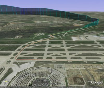
Out of all the geocaching-related mapping programs including the various Google Earth overlays, this simple online utility has by-far the most WOW factor. This short tutorial is designed to quickly help you take a simple GPX track file downloaded from your GPS to a fully interactive and color-coded map on Google Earth.
  1. Begin by downloading your own GPX track file from your GPSr or by using my sample file, here.
  2. Visit the GPS Visualizer Map page, http://www.gpsvisualizer.com/map.
  3. Change the first drop down box called "Output format:" to Google Earth and allow the page to switch you to the specialized Google Earth form.
  4. Change "Altitude mode:" to your preferred style. For my flight path example, I selected "Extruded."
  5. Change "Colorize by:" to your preferred style. For my flight path example, I selected "Speed." All other options on this page are completely optional and do not need to be changed from the defaults.
  6. In the right-hand column, click Browse and find your saved GPX track file.
  7. Click "Create KML file" button and view your results!
Note: If you have an older computer and can not use Google Earth, you may still follow the general steps above except on Step 3, you may choose Google Maps or another image format. However, your result will be 2-dimensional instead of 3-D.

Monday, May 29, 2006

How to Go Geocaching

http://www.wikihow.com/ is the newest site from the company that brought the world eHow.com. "wikiHow is a collaborative writing project aiming to build the world's largest how-to manual. Our mission is to provide free and useful instructions to help people solve the problems of everyday life."

wikiHow.com also contains one of the best over-all "How to Go Geocaching" guides that I've seen to date. But the best part is that since it is a wiki, it can get even better!

Monday, May 22, 2006

Leave No Trace

In keeping with last week's theme of environmental awareness, I thought I should also mention another great non-profit organization called Leave No Trace. The Leave No Trace Center for Outdoor Ethics is an international nonprofit organization dedicated to promoting and inspiring responsible outdoor recreation through education, research and partnerships.

There are 7 principles of the Leave No Trace program:
(information obtained from http://www.scouting.org/boyscouts/resources/21-105)
Plan Ahead and Prepare
Travel and Camp on Durable Surfaces
Dispose of Waste Properly
Leave What You Find
Minimize Campfire Impacts
Respect Wildlife
Be Considerate of Other Visitors
An excellent article edited by Ken Braband was published online in April 2002 on the Wisconsin Geocaching Association website about this topic and how it relates to Geocachers simply entitled "Leave No Trace."
 

Friday, May 19, 2006

Tread Lightly: Responsible Geocaching

After digging through the Groundspeak forums for more information about Tread Lightly, I came across a fairly short thread in which Jeremy Irish posted a link to a Tread Lightly guide that he helped author entitled "Responsible Geocaching". This article is in the same format as the other published Tread Lightly guides for responsible hiking, camping and boating which can all be found on the main treadlightly.org website. The organization has also formatted this guide into a really well designed PDF brochure that I highly recommend viewing.

Thursday, May 18, 2006

Geocachers Encouraged to Tread Lightly

Article by Treadlightly.org

Marrying high-tech gadgets with rugged outdoor travel, geocaching has become one of the hottest new forms of recreation. But some are warning that its popularity will take a toll on the nation’s public land if not done responsibly.

In geocaching, participants use global positioning systems (GPS) to direct them to hidden treasures or “caches.” Caches are usually low-priced trinkets and are most often placed in backcountry settings. There are at least 250,000 caches hidden throughout the world on any given day.

“Unwanted tire tracks, damaged vegetation and disrupted wildlife can be harsh consequences of irresponsible geocaching,” said Patti Klein, National Stewardship Coordinator for the Bureau of Land Management. “We encourage geocachers to check with their local land manager for regulations and practice minimum impact behavior at all times.”

"Tread Lightly!," a nonprofit organization that educates people to recreate responsibly, recently released tips to help geocachers minimize their impact on the outdoors.

TIPS FOR RESPONSIBLE GEOCACHING
  • Check with local land managers to determine regulations before placing or searching for a cache. The National Park Service, for example, has strict geocaching regulations.
  • Keep vehicles on designated roads and trails.
  • Use the “track back” feature on your GPS unit rather than flagging and marking trails.
  • In addition to your GPS receiver, always carry extra batteries, a map, compass and know how to use them.
  • Practice the “lift, look, replace” technique. If you lift a rock to look under it, replace it exactly as you found it.
  • Following a trip, wash your gear to reduce the spread of invasive species.
  • Traditional geocaching is not appropriate in areas designated as Wilderness.

CACHE PLACERS
  • Avoid sensitive areas including cultural sites, wetlands, caves and steep slopes.
  • Avoid burying a cache in the ground.
  • It is the cache owner's responsibility to maintain the cache and the surrounding area. If the cache area becomes impacted, confer with the landowner on how you will mitigate the impacts, and seek their advice as to whether to relocate the cache.
  • Never place food items in a cache.

CACHE SEEKERS
  • Use maps to find a route that will minimize impact.
  • If you notice a path has started to wear in the vicinity of a cache, notify the cache owner via email.
  • When allowed to hike off designated trails, spread out in open country. One exception is in deserts, where hikers should travel in single file and try to walk on hardened surfaces such as slickrock, gravel or in sand washes.
  • After you’ve finished searching for a cache, the area should look as though you were never there or better than when you arrived.
"It is important for the worldwide geocaching community to tread lightly on the environment in order to maintain the natural beauty of our outdoor resources,” said Bryan Roth, Co-Founder and Vice President of geocaching.com, the web’s dominant geocaching site.

Geocaching.com also created a program called “Cache In, Trash Out” to help the sport make a positive impression on public land. Further information can be found on their website.

Additional tips for responsible geocaching are available on Tread Lightly!’s website at www.treadlightly.org or by calling 1-800-966-9900.

Tread Lightly!(R) is a national nonprofit organization whose mission is to empower generations to enjoy the outdoors responsibly. Tread Lightly!’s strategic educational message, along with its training and restoration initiatives are designed to instill an ethic of responsibility in outdoor enthusiasts and the industries that serve them. The program is long-term in scope with a goal to balance the needs of the people who enjoy outdoor recreation with the needs of the environment.

CAPTION: JILL SCOTT, A GEOCACHER FROM OGDEN, UTAH, STUDIES HER GPS UNIT TO FIND A HIDDEN CACHE. GEOCACHERS ARE ASKED TO FOLLOW GUIDELINES TO HELP THEM MINIMIZE IMPACT ON THE ENVIRONMENT AS THEY HIDE AND SEEK.
 

Thursday, May 11, 2006

Good Presentations

I couldn't just leave my previous post to stand alone without providing at least a few examples of good presentations. There are other presentations out there that have a similar purpose without all the “shady” content. I highly recommend looking at these. The first one by the Wisconsin Geocaching organization is probably the best I've seen! If you know of other good presentations, please post links to them in the comments. I'd love to see what else is out there.

Wednesday, May 10, 2006

$12 Billion Dollar Hobby

I just came across this site http://www.lostgear.com/ and love their opening tag. Check it out!
GeoCaching is the only activity that requires $12 Billion dollars worth of equipment to participate.
That's right, one relatively cheap GPS unit, and $12 Billion U.S. dollars worth of satellite systems, and you're ready to play. Luckily the US government has already footed the bill for the satellite system, and put it out there. So all you need is the GPS, some walking shoes, and a sense of adventure. We'll wait right here while you gather these things together...

Saturday, March 18, 2006

Write a Good Geocaching Log

Most of the time, I pride myself in taking the time to sit down and write short, yet original cache logs on the Geocaching.com website for each of my finds. Unfortunately, at times, I fall into the trap of copy/paste logs - especially when I have just come back from a large cache run (or I just get lazy). This is a short excerpt from a blog post by Mike at jestcaching.com from last October. It is interesting reading.

jestcaching: Write a Good Geocaching Log
People that hide caches do so to share the experience with the finders. Most hiders look forward to reading the logs after somebody finds them. In most cases the hider puts more time into hiding and posting the cache than the geocacher that finds the cache. So why not reward the hider with a good log? We love reading logs telling the experience, especially ones that include some humor. It really makes our day to 1. know that somebody took the time to find one or our caches and 2. to hear about the fun (or sometimes frustration) they had while finding it. That being said we would like to introduce a couple of our favorite log writers.

Oregon is a geocacher on the West Coast that writes epic logs. He has not been very active lately and his profile says that he is over 200 logs behind. If you read some of his logs you can certainly understand why. Some could be considered short novels. They not only talk about finding the cache, but also getting there and sometimes what is going on with his life. They are hilarious. We have spent many nights just sitting in front of the computer laughing at his musings.

Closer to home we have a geocaching team named Yodadog. We have met the team several times and have even walked the trails with them and each time it seems weird. That is because they write their logs in the third person or should we say third canine? They have an adorable Corgi that has been personified in their logs. Seeing them this weekend we asked who got the most email - The Master, The Mistress, or Yoda. Seems Yoda wins hands down. Go to their profile and read some of their logs if you are in need for some entertainment and a good laugh.

Friday, February 24, 2006

What is Cacheopedia?


Cacheopedia is a wiki site to create an online encyclopedia / reference / survival guide for the sport of geocaching. It is a source for geocaching FAQs, articles, definitions, guides, and a whole lot more. Anyone can write an article about any geocaching-related subject that they wish. Readers can also improve articles that others have written.
I just recently discovered Cacheopedia and am thoroughly impressed by both the quantity and quality of the articles posted. Cacheopedia is basically a wiki site all about geocaching. It is similar in style and appearance to Wikipedia.com. I can promise that a link to Cacheopedia will soon appear in my updated Links section!
 

Tuesday, January 10, 2006

Software Review featured on PodCacher.com


PodCache (pod-kash)

n.
1. A store of goods or valuables concealed in a hiding place designed to be found by other "podcachers".
2. A game in which the players attempt to find hidden articles by means of a series of audio clues.
v. 1. A geeky techy fun new way to hide things (treasure stashes) for others to find. Combining the aspects of Podcasting and Geocaching.
Sonny and Sandy (iTrax and FoxTail) are the voices behind the best new podcast on the web dedicated solely to Geocaching, PodCacher.com. According to Wikipedia, podcaching is a combination of podcasting and geocaching. The PodCacher.com shows feature podcaches as well as Geocaching news, tips and tricks, tools of the trade, interviews, opinions, cache stories and experiences, and "live" on-the-field tours and hunts!

In their latest show, "Show 33: Geocaching Software," my entry about Geocaching Software tools was mentioned and praised! To listen to the part about this blog, download the show from the link above and forward to around 18 minutes into the show. Thank you Sonny and Sandy!!!!!
 

Friday, December 23, 2005

jestcaching: Geocaching Software

One of the more popular Geocaching blogs just posted a reference to my Geocaching Software entry. Thanks!

jestcaching: Geocaching Software
 

Thursday, December 22, 2005

Geocaching Software

To assist my geocaching endeavors, I often make use of several software programs to help organize and display cache information in ways that I need it. This is a list of my favorite programs and ones that I think really have caching potential.


GSAK
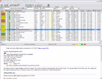
Geocaching Swiss Army Knife (GSAK) is an all-in-one GPX and waypoint managing system. It allows users to quickly download pocket query GPX files from email, load them into multiple databases, organize and sort waypoints by distance or location, view target locations on various online maps, and send the waypoints directly to your PDA or GPS receiver. GSAK automatically queries GPX files and color codes waypoints by Found/Not Found/Hidden/Unavailable. If you are looking for a program to help with waypoint management and GPS receiver transfers, this is the program to have. Registration for this program is just $20 and is worth every penny!

Geocaching Value:

CacheMate
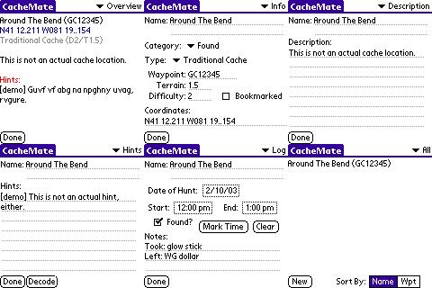
CacheMate is a program written for users of Palm-based PDA devices. This program allows PDA equipped Geocachers to take critical information with them into the field. CacheMate provides fingertip access to cache descriptions, decoded hints, and even previous log entries generated from GPX files or directly from GSAK. CacheMate has built-in sorting capabilities and can find nearby caches from any position by entering your current coordinates. Although I do not use CacheMate for this purpose, it can also be used to compose log entries in the field and keep a record of found caches and DNFs. For Geocachers who are looking to go paperless, this is the perfect solution and can be registered for only $8.

Geocaching Value:


CacheMaps
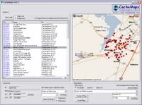
CacheMaps is a new discovery for me recently and one that I haven't had the opportunity to use in the field yet. It allows Geocachers to load an LOC file from GSAK or directly from geocaching.com and display those coordinates on online maps. However, its most useful feature for me is its offline map capabilities. Any map including its location, zoom, and cache position are automatically stored locally on your hard drive and are available at anytime even where there is no active Internet connection. This program allows Geocachers to browse through active cache lists and view current MapQuest or Expedia road maps even without an Internet connection while on geocaching road trips. Offline support for map services is currently limited in the United States to MapQuest and Expedia, but numerous online maps are available including Google maps. This program is currently marketed as donateware and you are able to purchase a registered version for any donation amount that you choose. Better get this one early while it's still improving and cheap!
Geocaching Value:


Google Earth
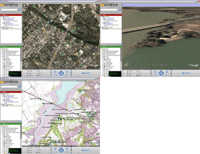
Google Earth is a 3D global mapping program originally developed by Keyhole and is now being released for free by Google. Its primary function is to display satellite and aerial photographs of the entire planet on a 3D model of the Earth. Using these photos, users can fly around the globe and view detailed images of almost any destination. It has particular value to Geocachers because you can either generate a KMZ file directly from GSAK or drag and drop any GPX file downloaded from Geocaching.com and fly to the cache location virtually. Once you are viewing a location, you can pan, tilt, and zoom in further to help identify the exact cache location. In addition, Google Earth supports image or network overlays. With overlays, you can have trail maps, topographical maps, or other useful information display in Google Earth on top of your satellite image which can really assist Geocachers in finding their way to the cache location. Google Earth is so effective in some instances that I've actually used it to find a cache without ever turning on my GPS receiver! Best of all, the basic version of Google Earth is FREE!

Geocaching Value:


GPX to Google Map Creator
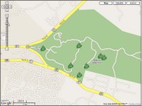
GPX to Google Map Creator is a really nice little program that allows users to easily upload GPX files created with GSAK or downloaded from Geocaching.com and display them in an online version of Google Maps. The map detail with Google Maps is not quite as high as it is with Google Earth, but these maps can be included on web pages and used by people without Windows XP. This program also allows Geocachers to display their tracks captured from a GPS receiver with GPSBabel. It is a great program for Geocachers to use for providing fully interactive maps of geocaching trips on personal websites or for printing out in advance of a geocaching trip. Caches are displayed on the Google maps with a Signal-the-Frog icon. This is an excellent little program that deserves 5 stars for its functionality even though its value to typical Geocachers is slightly lower than the other programs mentioned here.
Geocaching Value: