Showing posts with label Information. Show all posts

Monday, March 14, 2011

EarthCache Master

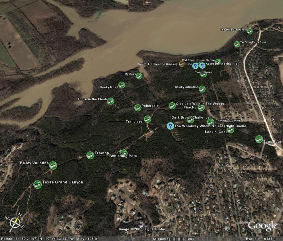
When I first began Geocaching in 2004 and throughout 2005, EarthCaches were extremely rare in Texas.  In fact, until December 2006, there were only three EarthCaches within a 200 mile radius of my home caching territory - the closest of those being almost 70 miles away.  Because of this, I have always viewed EarthCaches as somewhat of a rarity and something really special to be found.  It wasn't until October 2007 that I found my first EarthCache - Canyon Falls of McCormick's Creek (GC16PX4) in Indiana.

Last week, I found two more EarthCaches - just enough to qualify to become an "EarthCache Master" at the bronze level.  One of these EarthCaches was the one around 70 miles away from my home territory - Dinosaur Valley Earthcache (GCQMHY) in Dinosaur Valley State Park, TX.  If you've ever wanted to step inside *real* dinosaur footprints still in their natural state, this is the place to go!  The other cache was around 180 miles away - Wichita River (GC1PN9J) in Wichita Falls, TX. 

There are many other EarthCaches closer to my home territory now.  In fact, there are 73 EarthCaches within the same 200 mile radius at the time I wrote this post with some created as recently as last month.

So what exactly are EarthCaches?

EarthCaching is an Earth science/geography-based educational activity that draws from the ever-increasing use of GPS receivers and the growing popularity of geocaching. Educators and others realize that Earth itself offers its own treasures to uncover and endless opportunities for exploration, discovery, and learning. EarthCache sites, then, are “virtual” caches that provide the visitor who finds them with new knowledge or insights about the location itself - an “educational treasure” which is arguably more valuable than a trinket anyway!

Instead of leaving or taking anything from the site, visitors are asked to follow the EarthCache notes, make and record observations while at the site, and then log their visit on the EarthCache web site by reporting what they learned. Like geocaches, EarthCaches are developed by people all over the world. However, because they are meant to be educational, all EarthCache sites that are posted on the EarthCache web site must provide some scientific information about the site. All EarthCache locations that are submitted for posting are subject to approval and oversight by the Geological Society of America (GSA).
http://rock.geosociety.org/Earthcache/WebBook/EarthCaching_EducatorsGuide.pdf

If you are interested in EarthCaches, I recommend that you begin by visiting the http://earthcache.org/ website to learn more about this cache type and then search for EarthCaches near you on the http://geocaching.com/ website.  Once you find at least three EarthCaches in at least two states/countries, you too can qualify to become an EarthCache Master.

Monday, May 29, 2006

How to Go Geocaching

http://www.wikihow.com/ is the newest site from the company that brought the world eHow.com. "wikiHow is a collaborative writing project aiming to build the world's largest how-to manual. Our mission is to provide free and useful instructions to help people solve the problems of everyday life."

wikiHow.com also contains one of the best over-all "How to Go Geocaching" guides that I've seen to date. But the best part is that since it is a wiki, it can get even better!

Monday, May 22, 2006

Leave No Trace

In keeping with last week's theme of environmental awareness, I thought I should also mention another great non-profit organization called Leave No Trace. The Leave No Trace Center for Outdoor Ethics is an international nonprofit organization dedicated to promoting and inspiring responsible outdoor recreation through education, research and partnerships.

There are 7 principles of the Leave No Trace program:
(information obtained from http://www.scouting.org/boyscouts/resources/21-105)
Plan Ahead and Prepare
Travel and Camp on Durable Surfaces
Dispose of Waste Properly
Leave What You Find
Minimize Campfire Impacts
Respect Wildlife
Be Considerate of Other Visitors
An excellent article edited by Ken Braband was published online in April 2002 on the Wisconsin Geocaching Association website about this topic and how it relates to Geocachers simply entitled "Leave No Trace."
 

Friday, May 19, 2006

Tread Lightly: Responsible Geocaching

After digging through the Groundspeak forums for more information about Tread Lightly, I came across a fairly short thread in which Jeremy Irish posted a link to a Tread Lightly guide that he helped author entitled "Responsible Geocaching". This article is in the same format as the other published Tread Lightly guides for responsible hiking, camping and boating which can all be found on the main treadlightly.org website. The organization has also formatted this guide into a really well designed PDF brochure that I highly recommend viewing.

Thursday, May 18, 2006

Geocachers Encouraged to Tread Lightly

Article by Treadlightly.org

Marrying high-tech gadgets with rugged outdoor travel, geocaching has become one of the hottest new forms of recreation. But some are warning that its popularity will take a toll on the nation’s public land if not done responsibly.

In geocaching, participants use global positioning systems (GPS) to direct them to hidden treasures or “caches.” Caches are usually low-priced trinkets and are most often placed in backcountry settings. There are at least 250,000 caches hidden throughout the world on any given day.

“Unwanted tire tracks, damaged vegetation and disrupted wildlife can be harsh consequences of irresponsible geocaching,” said Patti Klein, National Stewardship Coordinator for the Bureau of Land Management. “We encourage geocachers to check with their local land manager for regulations and practice minimum impact behavior at all times.”

"Tread Lightly!," a nonprofit organization that educates people to recreate responsibly, recently released tips to help geocachers minimize their impact on the outdoors.

TIPS FOR RESPONSIBLE GEOCACHING
  • Check with local land managers to determine regulations before placing or searching for a cache. The National Park Service, for example, has strict geocaching regulations.
  • Keep vehicles on designated roads and trails.
  • Use the “track back” feature on your GPS unit rather than flagging and marking trails.
  • In addition to your GPS receiver, always carry extra batteries, a map, compass and know how to use them.
  • Practice the “lift, look, replace” technique. If you lift a rock to look under it, replace it exactly as you found it.
  • Following a trip, wash your gear to reduce the spread of invasive species.
  • Traditional geocaching is not appropriate in areas designated as Wilderness.

CACHE PLACERS
  • Avoid sensitive areas including cultural sites, wetlands, caves and steep slopes.
  • Avoid burying a cache in the ground.
  • It is the cache owner's responsibility to maintain the cache and the surrounding area. If the cache area becomes impacted, confer with the landowner on how you will mitigate the impacts, and seek their advice as to whether to relocate the cache.
  • Never place food items in a cache.

CACHE SEEKERS
  • Use maps to find a route that will minimize impact.
  • If you notice a path has started to wear in the vicinity of a cache, notify the cache owner via email.
  • When allowed to hike off designated trails, spread out in open country. One exception is in deserts, where hikers should travel in single file and try to walk on hardened surfaces such as slickrock, gravel or in sand washes.
  • After you’ve finished searching for a cache, the area should look as though you were never there or better than when you arrived.
"It is important for the worldwide geocaching community to tread lightly on the environment in order to maintain the natural beauty of our outdoor resources,” said Bryan Roth, Co-Founder and Vice President of geocaching.com, the web’s dominant geocaching site.

Geocaching.com also created a program called “Cache In, Trash Out” to help the sport make a positive impression on public land. Further information can be found on their website.

Additional tips for responsible geocaching are available on Tread Lightly!’s website at www.treadlightly.org or by calling 1-800-966-9900.

Tread Lightly!(R) is a national nonprofit organization whose mission is to empower generations to enjoy the outdoors responsibly. Tread Lightly!’s strategic educational message, along with its training and restoration initiatives are designed to instill an ethic of responsibility in outdoor enthusiasts and the industries that serve them. The program is long-term in scope with a goal to balance the needs of the people who enjoy outdoor recreation with the needs of the environment.

CAPTION: JILL SCOTT, A GEOCACHER FROM OGDEN, UTAH, STUDIES HER GPS UNIT TO FIND A HIDDEN CACHE. GEOCACHERS ARE ASKED TO FOLLOW GUIDELINES TO HELP THEM MINIMIZE IMPACT ON THE ENVIRONMENT AS THEY HIDE AND SEEK.
 

Thursday, May 11, 2006

Good Presentations

I couldn't just leave my previous post to stand alone without providing at least a few examples of good presentations. There are other presentations out there that have a similar purpose without all the “shady” content. I highly recommend looking at these. The first one by the Wisconsin Geocaching organization is probably the best I've seen! If you know of other good presentations, please post links to them in the comments. I'd love to see what else is out there.

Muddy Cachers

Well if I feel tomorrow
Like I feel today
I'm gonna pack my GPS
And make my getaway
Lord I'm troubled,
I'm all worried in mind
And I'm never bein' so horrified,
And I just can't keep from cryin'
-- Muddy Cachers
(original lyrics by Muddy Waters)

I just got done listening to the greatest and really only podcast about geocaching and heard a recommendation for a PowerPoint presentation used to help educate Police and or other law enforcement officers about geocaching. The presentation in question showed photos of geocachers sneaking behind bleachers, climbing over guardrails out onto bridge girders, and finding containers near concrete bridge supports. It also had several photos of ammunition boxes with the military markings still visible and even a huge buried cache! The presentation began by showing excerpts from news articles of geocachers falling to their death, being arrested for hanging buckets from a major overpass, and having cache containers blown up by bomb squads outside of police stations.
I know ALL of this has happened and is public knowledge, but why on earth would you choose this stuff when giving a presentation to police officers about geocaching?
If you want law enforcement officers to learn about geocaching as a family-friendly, outdoor-loving, eco-friendly and police-friendly sport, show them the good stuff!!! Show them the pictures of Brandon's kids, or some informational articles on jestcaching, or some of the great stories about kid's geocaching birthday parties on the PodCacher site, or even photos of a bunch of city-slickers about to kayak down a river in central Texas. Tell them about Cache-In, Trash-Out or about the Geocachers Creed.
Inform them about the sport, but do it the right way - "Safe, Legal, Ethical." Tell them what we do and how we do it, but make sure the examples you give show geocaching in a positive way. Make any presentation about geocaching seem like something they should try themselves and not something they should be on the look-out for.

Tuesday, March 14, 2006

Public Use of Private Texas Land

Land-owner permission and the right to use public and private land have been very hot topics lately on both my local and state geocaching boards as well as the Geocaching.com forums. The first of the two most recent complaints came from our biggest local cache complainer. He was attempting to find a cache along a Texas river-bank and had to cross "private property" in order to access the cache location by land. The second recent complaint from this same person was about a set of publicly accessible and frequently used hiking and biking trails known by local cachers simply as "The Woods." This second location is the home to two of my own caches, The Woodway Witch Project (Night Cache) and Trailblazer, in addition to almost two dozen other caches placed over the past 6 months.

Ultimately, the issue really boils down to three big points:

  1. EVERYTHING is owned by SOMEONE.
  2. Texas law permits certain public use of private land.
  3. You aren't trespassing unless you are told you are trespassing.
One fairly recent piece of Texas legislation, S.B. 155, dealth with several issues regarding public access to Texas waterways and river navigation. The following information comes from an article called "Driven to Act" by Bob Sweeny - Staff Attorney, Texas Parks and Wildlife Department.
Section 1 recognized that public access to Texas rivers is "a right granted to individuals under the Texas Constitution." To protect public access, the bill makes it a misdemeanor to restrict, obstruct, interfere with, or limit public recreational use of a protected freshwater area except as otherwise allowed by law. S.B. 155 also extends comparable protections to recreational river uses other than hunting or fishing, such as canoeing, or birdwatching [or geocaching]. It is widely recognized that prudent exercise of the constitutionally protected navigation right can entail temporary use of riverbanks to portage or scout obstructions, though the banks may be private property. Thus, under S.B. 155, if private riverside property is used to portage or scout obstructions, the landowner does not bear any risk of permanent loss of a property interest. Should it become unnecessary to use that particular riverside property (for example, because the river changes course), the public right of use disappears.
With this in mind, placing caches like Along the River should be no problem at all as long as the trail along the edge of the river itself is used to gain access to and scout the cache location.
The second complaint about caches in "The Woods" is also not really an issue when you actually read Texas trespassing laws. Section 30.05, Texas Penal Code, provides that a person commits an offense if the person enters or remains on property of another without effective consent, and the person:
  1. had notice that the entry was forbidden, or
  2. received notice to depart, but failed to do so.
Trespassing occurs after a person has been notified that the property is off-limits, but remains on the property (this excludes emergency workers performing their duties). There are five ways listed in Section 30.05 to notify the public that trespassing is not permitted:
  1. through verbal or written notification,
  2. fencing and similar enclosures,
  3. signs posted on the property that are visible by the public,
  4. visible presence of crops,
  5. and using purple paint to post the property.
The 'purple paint' law in Texas took effect in September of 1997. The law requires that the purple paint markings must be vertical, at least eight-inches long and one-inch wide. The bottom of the mark should be between three and five feet above the ground. The markings can be no more than 100 feet apart in timberland and 1,000 feet apart on open land, and must be in a place visible by those approaching the property.
Texas law actually has several provisions for Adverse Possession, Prescriptive Easements, and Implied Public Dedication that will legally transfer ownership of trespassed land to a trespasser or will legally grant a trespasser the right to use another's land. If a trespasser uses a piece of another's property for a certain amount of time, Texas can legally transfer ownership of that property to the trespasser as adverse possession. If the general public uses another's property for a roadway, trail, shortcut, or access to another property or public land, Texas can legally assign permanent rights to the trespassers under a prescriptive easement or mark it as implied public dedication to be open to the general public for a particular use.
Ultimately, I agree that placing caches on marked private property is a bad idea unless you have permission from the landowner for both the hide and for future finders. However, while I have no doubt that there are many who would disagree with me; I don't think there is anything wrong with placing caches on publicly accessible private land in Texas - especially when there is already a clearly defined set of trails enabling access to publicly protected lands like those along Texas lakes and rivers. After all, everything is owned by someone or some government. There are no more "public" lands waiting for a claim to be made.
We may never know exactly who owns "The Woods," since even the tax records seem to conflict on the exact ownership boundaries. The largest area appears to be owned by a defunct golf course corporation prior to the raising of the lake level almost a decade ago. This area has obviously been used for recreational hiking, biking and off-road purposes long before the geocachers invaded without complaints or trespass markings from landowners. In my opinion, this land has been made public through implied public dedication.
Disclaimer: Please note that none of the information contained in these posts is meant to be professional information or legal advise. Consult your attorney or other legal professional for their advice before engaging in any activity that could be considered trespassing.

Friday, March 10, 2006

The Original - Part 2

Prior to the GPS Stash Hunt website that I mentioned in my previous post, there existed one single defining event in the history of geocaching - the first cache! On May 3, 2000, Dave Ulmer (photo below from Geocaching.com cache page) posted a message on the sci.geo.satellite-nav USENET newsgroup announcing to the world that he had just hidden the "first stash hunt stash" in the woods outside of Portland, Oregon. With a single message, Dave Ulmer began the sport of Geocaching that has grown to include over 240,000 active caches in 220 countries!


From: Dave (news2yousNOneSPAM@hotmail.com.invalid)
Subject: GPS Stash Hunt... Stash #1 is there!
Newsgroups: sci.geo.satellite-nav
Date: 2000/05/03

Well, I did it, created the first stash hunt stash and here are the coordinates:

N 45 17.460
W122 24.800

Lots of goodies for the finders. Look for a black plastic bucket buried most of the way in the ground. Take some stuff, leave some stuff! Record it all in the log book. Have Fun!

Stash contians: Delorme Topo USA software, videos, books, food, money, and a slingshot!

Tuesday, March 07, 2006

The Original - Part 1

No, no, I'm not talking about the famous Scholtzsky's sandwich; I'm talking about the original Geocaching website created back in May 2000 shortly after the end of Selective Availability.

Thanks to the miracles of the Wayback Machine's web archiving abilities, it is possible to go back-in-time to visit old websites that are no longer in existence or previous versions of current websites. Using the Wayback Machine, it is possible to visit Mike Teague's original GPS Stash Hunt website which listed the rules of geocaching, provided the coordinates for all caches in the 11 states with caches, and provides links to Dave Ulmer's document entitled, "Introduction to Recreational Geocaching."

The following is a short excerpt from this original guide to Geocaching. The original can be viewed on the Wayback Machine.


Geocaching is a new 21st century recreation that came about as a result of the improving accuracy of electronic Global Positioning System (GPS) devices. With improved positional accuracy on the order of three meters, GPS's now allow unskilled users the ability to find geographic locations with precision and repeatability. With this new ability, people can now place geocaches in interesting places so that others can enjoy the challenge of finding them. This is called Recreational Geocaching.

Geocache and Geocaching are new words developed to easily communicate the act of placing an object at a geographical location and recording its position. Geocache can be used as a noun or a verb. A geocache is an item or group of items located at a recorded geographical position. To geocache, is to place the object and record its position. Geocaching, the act of placing or locating geocaches. Geocaching is also used to describe the sport or recreation of geocaching. A geocacher is a person involved in geocaching.

Thursday, December 22, 2005

Geocaching Software

To assist my geocaching endeavors, I often make use of several software programs to help organize and display cache information in ways that I need it. This is a list of my favorite programs and ones that I think really have caching potential.


GSAK
Geocaching Swiss Army Knife (GSAK) is an all-in-one GPX and waypoint managing system. It allows users to quickly download pocket query GPX files from email, load them into multiple databases, organize and sort waypoints by distance or location, view target locations on various online maps, and send the waypoints directly to your PDA or GPS receiver. GSAK automatically queries GPX files and color codes waypoints by Found/Not Found/Hidden/Unavailable. If you are looking for a program to help with waypoint management and GPS receiver transfers, this is the program to have. Registration for this program is just $20 and is worth every penny!

Geocaching Value:

CacheMate
CacheMate is a program written for users of Palm-based PDA devices. This program allows PDA equipped Geocachers to take critical information with them into the field. CacheMate provides fingertip access to cache descriptions, decoded hints, and even previous log entries generated from GPX files or directly from GSAK. CacheMate has built-in sorting capabilities and can find nearby caches from any position by entering your current coordinates. Although I do not use CacheMate for this purpose, it can also be used to compose log entries in the field and keep a record of found caches and DNFs. For Geocachers who are looking to go paperless, this is the perfect solution and can be registered for only $8.

Geocaching Value:


CacheMaps
CacheMaps is a new discovery for me recently and one that I haven't had the opportunity to use in the field yet. It allows Geocachers to load an LOC file from GSAK or directly from geocaching.com and display those coordinates on online maps. However, its most useful feature for me is its offline map capabilities. Any map including its location, zoom, and cache position are automatically stored locally on your hard drive and are available at anytime even where there is no active Internet connection. This program allows Geocachers to browse through active cache lists and view current MapQuest or Expedia road maps even without an Internet connection while on geocaching road trips. Offline support for map services is currently limited in the United States to MapQuest and Expedia, but numerous online maps are available including Google maps. This program is currently marketed as donateware and you are able to purchase a registered version for any donation amount that you choose. Better get this one early while it's still improving and cheap!
Geocaching Value:


Google Earth
Google Earth is a 3D global mapping program originally developed by Keyhole and is now being released for free by Google. Its primary function is to display satellite and aerial photographs of the entire planet on a 3D model of the Earth. Using these photos, users can fly around the globe and view detailed images of almost any destination. It has particular value to Geocachers because you can either generate a KMZ file directly from GSAK or drag and drop any GPX file downloaded from Geocaching.com and fly to the cache location virtually. Once you are viewing a location, you can pan, tilt, and zoom in further to help identify the exact cache location. In addition, Google Earth supports image or network overlays. With overlays, you can have trail maps, topographical maps, or other useful information display in Google Earth on top of your satellite image which can really assist Geocachers in finding their way to the cache location. Google Earth is so effective in some instances that I've actually used it to find a cache without ever turning on my GPS receiver! Best of all, the basic version of Google Earth is FREE!

Geocaching Value:


GPX to Google Map Creator
GPX to Google Map Creator is a really nice little program that allows users to easily upload GPX files created with GSAK or downloaded from Geocaching.com and display them in an online version of Google Maps. The map detail with Google Maps is not quite as high as it is with Google Earth, but these maps can be included on web pages and used by people without Windows XP. This program also allows Geocachers to display their tracks captured from a GPS receiver with GPSBabel. It is a great program for Geocachers to use for providing fully interactive maps of geocaching trips on personal websites or for printing out in advance of a geocaching trip. Caches are displayed on the Google maps with a Signal-the-Frog icon. This is an excellent little program that deserves 5 stars for its functionality even though its value to typical Geocachers is slightly lower than the other programs mentioned here.
Geocaching Value:


Wednesday, March 23, 2005

POISON IVY: The Bane of All Geocachers!

There are many evil plants in the world such as Henbane, Hemlock, Datura, Deadly Nightshade and Mandrake. But the most vile, contemptible, wretched, and loathsome of them all must be Toxicodendron radicans - POISON IVY!

After we purchased our new house last summer, we noticed that poison ivy was actively growing in our back yard. Unfortunately, I discovered it only after I was covered head-to-toe in the itchy rash that has come to plague me for the umpteenth time since my boy scout days as a child. If you are not aware of how poison ivy affects your body, a normally benign oil called Urushiol is produced by these plants and binds with your skin. Once bound to cell membranes, urushiol is virtually impossible to wash off and attached to cell membranes attracts patrolling T-cells and initiates a full-blown immune response which is the cause of the horrid rash. Each time you come into contact with poison ivy, your body learns how to "fight" it harder with an increased T-cell response.

To make this long story short, I hired a lawn service three times to come dig up the poison ivy found in our yard, and I followed by filling the holes with Roundup. For the remainder of the summer and fall, this seemed to do the trick. Every time that I had to mow or do other yard work, I had no recurring reaction - UNTIL NOW! This weekend, I decided to pick up the remaining leaves and ground clutter in our back yard by mowing the yard with the grass catcher attached. It did a fantastic job and yard looks great! But as Sunday night passed into Monday morning, I began noticing the ever-so-distinctive itching sensation under my right arm. Now, I'm covered once again!

Needless to say, each bout of poison ivy makes you hyper-sensitive to the three leafed plant in your surroundings, and this is how it relates to Geocaching. Even though my arms, legs, and chest are covered in this itchy rash, I decided I'd attempt to be an FTF at Anti-Q-Zoo near the old Waco Zoo. After I arrived in the abandoned parking lot, my GPS was guiding me near the edge of the lot towards the old fence line and some trees. As I approached the edge of the pavement, my eyes focused on one thing and one thing only near my feet! POISON IVY! Everywhere I looked, there was POISON IVY! There were a few patches of grass and tall weeds between the pavement and the fence, but through it all was POISON IVY! I truthfully don't think I've ever seen so much of this dreaded plant in one place in my entire life and I was about to trample right through it!

I'm afraid this will be one cache that will forever be on my forbidden list. In fact, I feel incredibly sorry for anyone who ventures near this cache and wonder how sawdust92 managed to hide it without being covered in the oils of this demon.