Showing posts with label Popular. Show all posts

Friday, June 30, 2006

Stats and Rankings

Stats! Huh-yeah.
What is it good for?
Absolutely nothing.
Uh-huh!


Many geocachers that I've met in person or online are absolutely obsessed with stats. You may even be one of them. If so, this post is for you!

Part of any great sport or game is the element of competition. Geocaching is no different! Well, almost no different. Geocaching is a little different because there are so many unregulated variables that make a true comparison virtually impossible. There are at least 5 different cache listing services - each with their own rules or guidelines. There are also so many different views of what makes a "good" hide or a "true" find.

  • Does a group hunt count for individual finds?
  • Does a find count if you've had to call or ask for help?
  • Are harder hides worth more than easier ones?
  • Should a foreign cache logged at a local event be allowed?
  • Can a find still be logged on disabled caches?
Personally, I think this short paragraph from a May 2005 article by Chuck Williams in LowCountry Weekly called "An Insider's Look at the Geocaching Controversy" sums this up the best.
In geocaching, everyone who seeks a geocache is a winner, whether they find the actual geocache container or not. The real thrills are the search and the locations, not the random key chains, Mickey D toys and other trinkets that fill a geocache container. The real nugget that the geocacher seeks is the logbook to sign and prove that s/he has really been there and found that. The scorecard is a personal one.
For me, the real thrill of geocaching is the hunt without all of the stats involved. But with that in mind, there are still several sites on the Internet dedicated solely to tracking stats and ranking geocachers based on their total number of hides, finds, and hide-to-find ratio. Even I'll confess to browsing these from time to time to see where I fit in the grand scheme of geocaching. These are two of the main national Geocacher Ranking sites.
  • KeenPeople.com Stats - This site allows geocachers to register themselves and record their own statistics from any listing service which are then used for the overall or state-wide rankings. Geocachers are allowed to enter how many of each type of cache they have found and hidden. Cachers can also record many other details like how many other Geocachers they've met, how many travel bugs they have found or released, how many times they have CITO'd a cache site, how many times they were FTF, or how many states they've cached.
  • Grand High Pobah - This site automatically grabs geocaching statistics from a select number of "high profile" Geocaching.com geocaches from each country and state. It only tracks the number of hides and finds from each cacher, but since it does it automatically, the stats are much more accurate and up-to-date than the other ranking sites. Unfortunately, this site only displays cachers with over 200 finds and cachers must have found one of the "high profile" geocaches in their state in order to appear in the rankings.

Monday, June 12, 2006

WiFi Caching Map - Revisited

Just over one year ago, I posted an article titled "WiFi Caching Map" that gave instructions on how to use your GPS receiver attached to a laptop computer running NetStumbler and a program called JiGLE to create a visual map of the various WiFi hotspots in your local area. The map from that original post looked like the one below. The results are decent and it is a fairly easy way to quickly see WiFi coverage in an area.


However, since my discovery of GPS Visualizer that I mentioned last week, I thought it would be a good idea to go wardriving once again and try out a new tool like GPS Visualizer. The instructions are basically the same as the previous tutorial, but instead of loading your file in JiGLE, you simply upload your file to GPS Visualizer and let it do all the work for you. GPS Visualizer uses your recorded NetStumbler coordinates and the signal strength of the detected wireless networks to map the approximate location of the source of the wireless access points that were detected. To create a map like this one on a Windows XP computer, follow these steps:
  1. Download and install NetStumbler from http://www.netstumbler.com/downloads/.
  2. Connect your GPS to your laptop with a data cable and configure your GPS to send a NMEA compatible signal in your Interface Setup screen.
  3. Start NetStumbler and begin driving through your neighborhood. Each time NetStumbler picks up a signal, it will show its listing on the main screen and generate an alert sound.
  4. When you are finished with your drive, close NetStumbler and save the NS1 file it generates for you on your desktop.
  5. Connect to the Internet and visit http://www.gpsvisualizer.com/map?form=wifi.
  6. Choose your preferred output type (SVG, JPG, PNG, Google Map, Google Earth KMZ, or Yahoo! Flash) from the Output Format drop-down box.
  7. It is not necessary to change any of the other options, but you can customize the results if you'd like.
  8. Browse for and upload your saved NetStumbler NS1 file from the left side menu.
  9. Click "Draw the Map" and view your results!
I've loaded several example images below to demonstrate the various types of output that GPS Visualizer can generate. These maps are all created from the same NetStumbler file in the same geographic area as the original JiGLE map above.


SVG Format with USGS Aerial photo

Google Street Map

Google Hybrid Map

Google Earth
 

Thursday, June 01, 2006

GPS Visualizer Tutorial

"GPS Visualizer is a free, easy-to-use online utility that creates maps and profiles from GPS data (tracks and waypoints), street addresses, or simple coordinates. Use it to see where you've been, plan where you're going, or visualize geographic data."

Out of all the geocaching-related mapping programs including the various Google Earth overlays, this simple online utility has by-far the most WOW factor. This short tutorial is designed to quickly help you take a simple GPX track file downloaded from your GPS to a fully interactive and color-coded map on Google Earth.
  1. Begin by downloading your own GPX track file from your GPSr or by using my sample file, here.
  2. Visit the GPS Visualizer Map page, http://www.gpsvisualizer.com/map.
  3. Change the first drop down box called "Output format:" to Google Earth and allow the page to switch you to the specialized Google Earth form.
  4. Change "Altitude mode:" to your preferred style. For my flight path example, I selected "Extruded."
  5. Change "Colorize by:" to your preferred style. For my flight path example, I selected "Speed." All other options on this page are completely optional and do not need to be changed from the defaults.
  6. In the right-hand column, click Browse and find your saved GPX track file.
  7. Click "Create KML file" button and view your results!
Note: If you have an older computer and can not use Google Earth, you may still follow the general steps above except on Step 3, you may choose Google Maps or another image format. However, your result will be 2-dimensional instead of 3-D.

Tuesday, March 14, 2006

Public Use of Private Texas Land

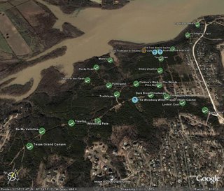
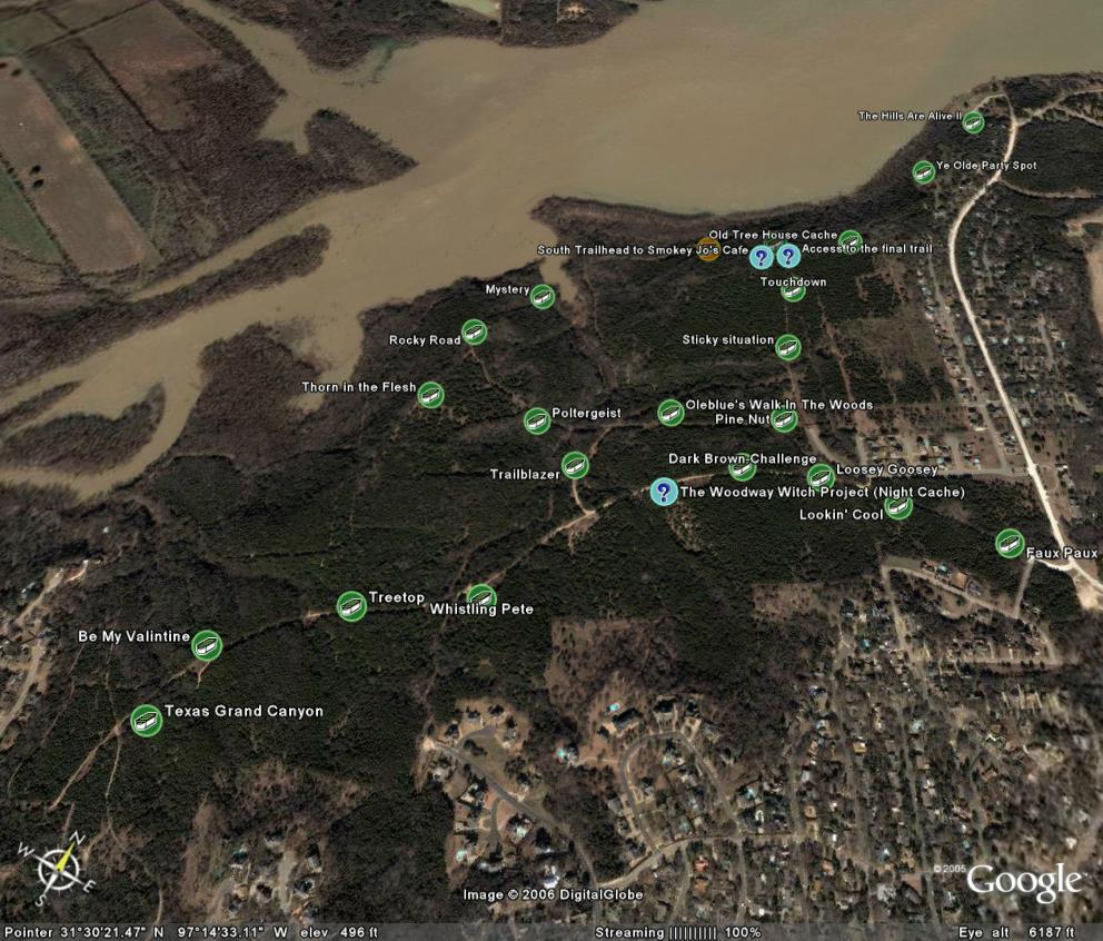
Land-owner permission and the right to use public and private land have been very hot topics lately on both my local and state geocaching boards as well as the Geocaching.com forums. The first of the two most recent complaints came from our biggest local cache complainer. He was attempting to find a cache along a Texas river-bank and had to cross "private property" in order to access the cache location by land. The second recent complaint from this same person was about a set of publicly accessible and frequently used hiking and biking trails known by local cachers simply as "The Woods." This second location is the home to two of my own caches, The Woodway Witch Project (Night Cache) and Trailblazer, in addition to almost two dozen other caches placed over the past 6 months.

Ultimately, the issue really boils down to three big points:

  1. EVERYTHING is owned by SOMEONE.
  2. Texas law permits certain public use of private land.
  3. You aren't trespassing unless you are told you are trespassing.
One fairly recent piece of Texas legislation, S.B. 155, dealth with several issues regarding public access to Texas waterways and river navigation. The following information comes from an article called "Driven to Act" by Bob Sweeny - Staff Attorney, Texas Parks and Wildlife Department.
Section 1 recognized that public access to Texas rivers is "a right granted to individuals under the Texas Constitution." To protect public access, the bill makes it a misdemeanor to restrict, obstruct, interfere with, or limit public recreational use of a protected freshwater area except as otherwise allowed by law. S.B. 155 also extends comparable protections to recreational river uses other than hunting or fishing, such as canoeing, or birdwatching [or geocaching]. It is widely recognized that prudent exercise of the constitutionally protected navigation right can entail temporary use of riverbanks to portage or scout obstructions, though the banks may be private property. Thus, under S.B. 155, if private riverside property is used to portage or scout obstructions, the landowner does not bear any risk of permanent loss of a property interest. Should it become unnecessary to use that particular riverside property (for example, because the river changes course), the public right of use disappears.
With this in mind, placing caches like Along the River should be no problem at all as long as the trail along the edge of the river itself is used to gain access to and scout the cache location.
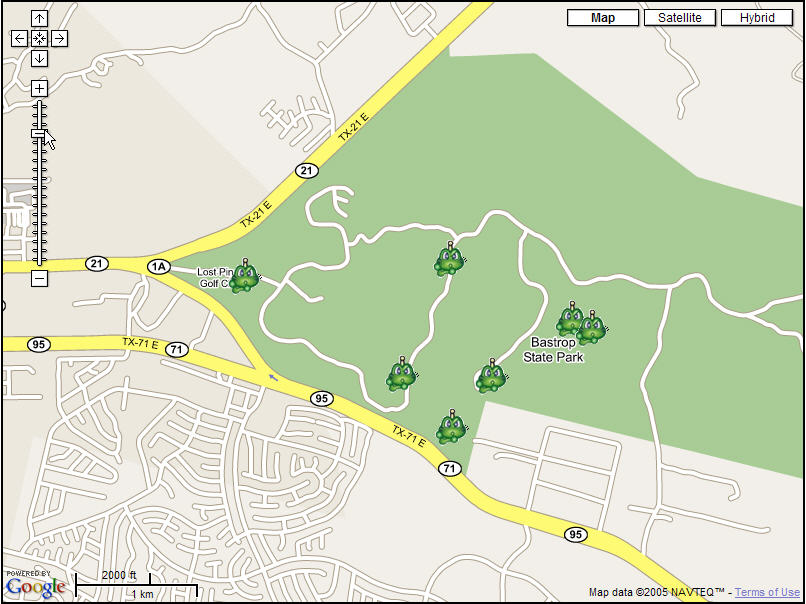
The second complaint about caches in "The Woods" is also not really an issue when you actually read Texas trespassing laws. Section 30.05, Texas Penal Code, provides that a person commits an offense if the person enters or remains on property of another without effective consent, and the person:
  1. had notice that the entry was forbidden, or
  2. received notice to depart, but failed to do so.
Trespassing occurs after a person has been notified that the property is off-limits, but remains on the property (this excludes emergency workers performing their duties). There are five ways listed in Section 30.05 to notify the public that trespassing is not permitted:
  1. through verbal or written notification,
  2. fencing and similar enclosures,
  3. signs posted on the property that are visible by the public,
  4. visible presence of crops,
  5. and using purple paint to post the property.
The 'purple paint' law in Texas took effect in September of 1997. The law requires that the purple paint markings must be vertical, at least eight-inches long and one-inch wide. The bottom of the mark should be between three and five feet above the ground. The markings can be no more than 100 feet apart in timberland and 1,000 feet apart on open land, and must be in a place visible by those approaching the property.
Texas law actually has several provisions for Adverse Possession, Prescriptive Easements, and Implied Public Dedication that will legally transfer ownership of trespassed land to a trespasser or will legally grant a trespasser the right to use another's land. If a trespasser uses a piece of another's property for a certain amount of time, Texas can legally transfer ownership of that property to the trespasser as adverse possession. If the general public uses another's property for a roadway, trail, shortcut, or access to another property or public land, Texas can legally assign permanent rights to the trespassers under a prescriptive easement or mark it as implied public dedication to be open to the general public for a particular use.
Ultimately, I agree that placing caches on marked private property is a bad idea unless you have permission from the landowner for both the hide and for future finders. However, while I have no doubt that there are many who would disagree with me; I don't think there is anything wrong with placing caches on publicly accessible private land in Texas - especially when there is already a clearly defined set of trails enabling access to publicly protected lands like those along Texas lakes and rivers. After all, everything is owned by someone or some government. There are no more "public" lands waiting for a claim to be made.
We may never know exactly who owns "The Woods," since even the tax records seem to conflict on the exact ownership boundaries. The largest area appears to be owned by a defunct golf course corporation prior to the raising of the lake level almost a decade ago. This area has obviously been used for recreational hiking, biking and off-road purposes long before the geocachers invaded without complaints or trespass markings from landowners. In my opinion, this land has been made public through implied public dedication.
Disclaimer: Please note that none of the information contained in these posts is meant to be professional information or legal advise. Consult your attorney or other legal professional for their advice before engaging in any activity that could be considered trespassing.

Tuesday, March 07, 2006

The Original - Part 1

No, no, I'm not talking about the famous Scholtzsky's sandwich; I'm talking about the original Geocaching website created back in May 2000 shortly after the end of Selective Availability.

Thanks to the miracles of the Wayback Machine's web archiving abilities, it is possible to go back-in-time to visit old websites that are no longer in existence or previous versions of current websites. Using the Wayback Machine, it is possible to visit Mike Teague's original GPS Stash Hunt website which listed the rules of geocaching, provided the coordinates for all caches in the 11 states with caches, and provides links to Dave Ulmer's document entitled, "Introduction to Recreational Geocaching."

The following is a short excerpt from this original guide to Geocaching. The original can be viewed on the Wayback Machine.


Geocaching is a new 21st century recreation that came about as a result of the improving accuracy of electronic Global Positioning System (GPS) devices. With improved positional accuracy on the order of three meters, GPS's now allow unskilled users the ability to find geographic locations with precision and repeatability. With this new ability, people can now place geocaches in interesting places so that others can enjoy the challenge of finding them. This is called Recreational Geocaching.

Geocache and Geocaching are new words developed to easily communicate the act of placing an object at a geographical location and recording its position. Geocache can be used as a noun or a verb. A geocache is an item or group of items located at a recorded geographical position. To geocache, is to place the object and record its position. Geocaching, the act of placing or locating geocaches. Geocaching is also used to describe the sport or recreation of geocaching. A geocacher is a person involved in geocaching.

Monday, January 09, 2006

Texas County Challenge

After recently hearing about the various DeLorme Challenges mentioned on a recent PodCacher podcast, I decided to look into doing something similar for Texas. When I first brought this idea to PrimeApprover, he recommended doing a County Challenge instead of a DeLorme Challenge because of the commercial implications of the DeLorme Challenges. With this in mind, I am pleased to announce the first DeLorme spin-off cache - the Texas County Challenge!


What is the Texas County Challenge?
Texas is a massive state with over 268,000 square miles spread out across 254 counties. The goal of this cache is to find or hide a cache in each and every county in Texas! The final cache coordinates can be obtained by successfully finding or hiding a cache in each county and then contacting me via email.

In order to claim this cache, you must first send me a file containing all of your hides and/or finds relative to this challenge. GPX or LOC format is required. I will review the list and generate a map showing their locations in order to verify the list. Once everything checks out, I will then send you the correct coordinates for the final cache! The find cannot be logged until the final physical container is found and the logbook inside signed.
Based on feedback from and incidents seen with similar challenges in other states, some guidelines need to be laid out:
  1. As mentioned above, the posted coordinates are not the actual coordinates for the cache. The actual cache may actually be quite some distance from these coordinates!
  2. Generally accepted rules, guidelines and conditions for logging or hiding a cache apply. These must be bona fide caches listed on Geocaching.com that you have personally (physically) found and logged. You may include caches found or hidden prior to the creation of the Texas County Challenge so long as they meet all other challenge requirements.
  3. Placement of a cache in a county counts the same as finding a cache in that county. Any previous hides may count towards completion of this challenge. Remember that any caches placed need to meet the geocaching.com guidelines. Don't place a cache that you can't maintain.
  4. All cache types count as finds or hides for the Texas County Challenge except for locationless caches. We are a friendly state, so even events and CITO events may be included.
  5. While county lines occasionally move and different versions of various maps may differ in exact boundary lines, the county lines derived from the information in the cache owner's copy of Google Earth will be considered definitive. Please feel free to check your GPX file with Google Earth prior to submission!
  6. While you may have others with you when you find the final cache, only those who have fulfilled ALL criteria for this cache will be allowed to log it as a find. Find logs by other cachers who have not completed the challenge will be deleted.
  7. When in doubt ask—we can discuss it or even seek guidance from others, but the final decision rests with the cache owner.
  8. The first 5 cachers who complete this challenge will receive a small commemorative gift at the completion of the challenge.
  9. A Texas County map can be obtained here.
  10. Remember that this is a game and is supposed to be fun!
Many thanks go out to Haicoole for the original idea for this type of challenge cache and to Moun10Bike for advice and assistance with the description. Also, thanks go to Sonny and Sandy for giving me this idea from their PodCacher podcast.
 

Thursday, December 22, 2005

Geocaching Software

To assist my geocaching endeavors, I often make use of several software programs to help organize and display cache information in ways that I need it. This is a list of my favorite programs and ones that I think really have caching potential.


GSAK
Geocaching Swiss Army Knife (GSAK) is an all-in-one GPX and waypoint managing system. It allows users to quickly download pocket query GPX files from email, load them into multiple databases, organize and sort waypoints by distance or location, view target locations on various online maps, and send the waypoints directly to your PDA or GPS receiver. GSAK automatically queries GPX files and color codes waypoints by Found/Not Found/Hidden/Unavailable. If you are looking for a program to help with waypoint management and GPS receiver transfers, this is the program to have. Registration for this program is just $20 and is worth every penny!

Geocaching Value:

CacheMate
CacheMate is a program written for users of Palm-based PDA devices. This program allows PDA equipped Geocachers to take critical information with them into the field. CacheMate provides fingertip access to cache descriptions, decoded hints, and even previous log entries generated from GPX files or directly from GSAK. CacheMate has built-in sorting capabilities and can find nearby caches from any position by entering your current coordinates. Although I do not use CacheMate for this purpose, it can also be used to compose log entries in the field and keep a record of found caches and DNFs. For Geocachers who are looking to go paperless, this is the perfect solution and can be registered for only $8.

Geocaching Value:


CacheMaps
CacheMaps is a new discovery for me recently and one that I haven't had the opportunity to use in the field yet. It allows Geocachers to load an LOC file from GSAK or directly from geocaching.com and display those coordinates on online maps. However, its most useful feature for me is its offline map capabilities. Any map including its location, zoom, and cache position are automatically stored locally on your hard drive and are available at anytime even where there is no active Internet connection. This program allows Geocachers to browse through active cache lists and view current MapQuest or Expedia road maps even without an Internet connection while on geocaching road trips. Offline support for map services is currently limited in the United States to MapQuest and Expedia, but numerous online maps are available including Google maps. This program is currently marketed as donateware and you are able to purchase a registered version for any donation amount that you choose. Better get this one early while it's still improving and cheap!
Geocaching Value:


Google Earth
Google Earth is a 3D global mapping program originally developed by Keyhole and is now being released for free by Google. Its primary function is to display satellite and aerial photographs of the entire planet on a 3D model of the Earth. Using these photos, users can fly around the globe and view detailed images of almost any destination. It has particular value to Geocachers because you can either generate a KMZ file directly from GSAK or drag and drop any GPX file downloaded from Geocaching.com and fly to the cache location virtually. Once you are viewing a location, you can pan, tilt, and zoom in further to help identify the exact cache location. In addition, Google Earth supports image or network overlays. With overlays, you can have trail maps, topographical maps, or other useful information display in Google Earth on top of your satellite image which can really assist Geocachers in finding their way to the cache location. Google Earth is so effective in some instances that I've actually used it to find a cache without ever turning on my GPS receiver! Best of all, the basic version of Google Earth is FREE!

Geocaching Value:


GPX to Google Map Creator
GPX to Google Map Creator is a really nice little program that allows users to easily upload GPX files created with GSAK or downloaded from Geocaching.com and display them in an online version of Google Maps. The map detail with Google Maps is not quite as high as it is with Google Earth, but these maps can be included on web pages and used by people without Windows XP. This program also allows Geocachers to display their tracks captured from a GPS receiver with GPSBabel. It is a great program for Geocachers to use for providing fully interactive maps of geocaching trips on personal websites or for printing out in advance of a geocaching trip. Caches are displayed on the Google maps with a Signal-the-Frog icon. This is an excellent little program that deserves 5 stars for its functionality even though its value to typical Geocachers is slightly lower than the other programs mentioned here.
Geocaching Value:


Sunday, October 23, 2005

The Woodway Witch Project

In the spirit of Halloween, a couple of my co-workers and I have decided to hide a night cache deep in the woods with a little surprise. The plan is to have the geocachers hike down an old trail through the woods until they reach a much smaller path that intersects the main trail. Here, they are required to make their way down this small path until they reach a clearing with large rocks set up to look like a small abandoned cemetery. Once there, the cachers must turn off their lights and allow their eyes to adjust to the darkness in order to see a small glowing light coming from just outside the left edge of the clearing. Finally, once they reach the light, the cache container will be within a few feet. Unfortunately for them, as soon as they find the cache and let their guard down, a creepy skeleton thing will be released and swing out of the trees toward the cachers.

To make the geocaching.com cache page look just as freaky, I've created an animated GIF graphic that will help introduce the cache. This is the small version. Click here to see the final, full-size version.


Saturday, October 01, 2005

Brazos River Expedition

Against the wind
I’m still runnin’ against the wind
Well I’m older now and still
Against the wind
Bob Seager (Against The Wind)

Today, five brave souls entered the Brazos River near Lake Whitney and only 3 came out alive. (The other two are still alive, just not so brave anymore.) Three of our party pushed forward with great gusto and would have finished this trip in under 4 hours. The other two, myself included, pushed forward with mediocre gusto and still finished in just a little over 4 hours.
Overall, the conditions were perfect! The temperature was a steady 85 degrees with nice cloud cover and a soft breeze all the way until we reached the cache location. Unfortunately, the water level was a little low and we had to drag over the rocks a couple of times. Some of us did have a few balance problems at first and tipped over within the first 10 feet of our voyage (ok, it was just me). Because there wasn't much water flow from the dam, we did have to work pretty hard for the first half.
Once we reached the cache location, it was an amazing experience! After thousands of years of erosion, the water had carved its way deep under one of the embankments. Since the water level was so low, we were able to kayak under this overhang and that was an incredible view! The climb up was a little scary since a fall would have been about 16 feet down into shallow water over rocks and boulders. The cache tower itself might be better renamed "Ivy Tower" since one entire side of the tower is covered in my three-leafed friend. Once the cache was signed by all, we took a break for some snacks before continuing down the river another 5 miles.
The middle portion of our trip was fairly uneventful except for a brief run-in with a couple of locals. This brought back horrid memories of the movie "Deliverance." We all had choruses of "Dueling Banjos" running through our heads and I half expected one of them to holler out "This river don't go to Aquilla. You done taken a wrong turn." Soon, they got back in their airboat adorned with confederate flags and went to another part of the river to continue their business, and we continued down the river with ours.
Those last few lines of "Against the Wind" describe in great detail the last portion of this trip. By this point in the morning, the sun had escaped from the clouds. The wind had also escaped from somewhere and was fleeing right towards us! Luckily, to our great advantage, the river became much narrower and we had a fairly steady current pushing us forward against the wind that was doing everything in its power to push us back. Finally, with the bridge in sight, we pushed forward and managed to complete this remarkable journey in just over 4 hours!